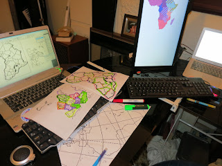
It was most important to not be biased in pieces sizes.
It’s necessary to have a minimum piece size for physical practicality -- it goes without saying that it would be ludicrous to have one-piece-per-country as some countries are imperceptibly small at this scale.
Though it’s very difficult to ascertain the precise area of any given piece and obviously they are all going to be irregularly shaped. It was also virtually impossible to intuit what a minimum size should be working in the abstract scalable vectors in the software.
Constantly zooming in and out and preserving perfect focus (as scalable vectors allow of course, like zooming in on the text of a PDF) makes if very difficult to keep perspective. The entire workspace is 1.4 metres (yes, 1400mm) long, yet I’ll usually be working at 10s of centimetres at a time and “looking at a border” scale is about 5cm.
Therefore physical tests pieces to hold and play with would be necessary.
South and Central America were used in the first print test to get an idea of piece sizes.
As Central America has a densely populated area with small countries it was good to use as a “rule of thumb” and started drawing up pieces that felt like they was right based on the following factor:
Where possible pieces they were grouped by some cultural grouping.
I spent time studying a range of different ways of grouping countries: Economic regions (useful for Africa), Languages, Religions (discussed further later) and a range of other more general groupings such as ethnicities and political history (useful for the Carribean).
I didn’t agonise on decisions but tried to be faithful to cultural divisions. I redivided and merged pieces as I came across different snippets of culturally interesting information, such as breaking out Cuba into its own piece quite late, and merging Djibouti with Somalia when all the way along I’d had it in with Ethiopia and Eritrea.
From this first pre-physical-test pass at Central America “20mm in some dimension” seemed to be a fair minimum. VCarve has grid points at 5mm intervals, this made the minimum a count-of-4-grid-pips within a piece and a fair bit eye-balling.
Turns out that in practice I decided this was pretty small, and I adjusted “up” a bit in practice.
Yet a small number of pieces *are* this small when it turns out that there just is no reasonable way to group otherwise.


